Sunday, December 19, 2010

Will Bing Crosby Grant Us All Our Wish?

In case you haven't heard, us weather people have been discussing the potential for a major winter storm in the Mid Atlantic on Saturday, Christmas.  Of course, this means, a chance of snow, on Christmas Day.

So here's what is up:  Sometime during the Tuesday - Wednesday time frame, a low pressure from the Pacific, will enter the Continental United States around the San Francisco Bay area.  This is a good position for snow in the Mid Atlantic - and I'll tell you why.  It is a general rule in meteorology, that any storm system will leave the US at the same lattitude, as it entered.  So this means, that the storm will probably leave the US somewhere off the NC/VA coastline, a favorable position for us to get snow. 

Now there are a few scenarios that I will try to explain. 
Scenario One -  The storm enters somewhere just South of San Francisco, and goes straight accross the country, leaving the East Coast somewhere around Hatteras, and kind of goes up the coast - but does not blow into a Noreaster. - this would spread a swath of  moderate snow accross much of the Mid Atlantic from Boone, NC to New York City.  I would say right now this would be a pretty good possibility.


Scenario 2:  The storm enters much further South than expect, - sparing the Mid Atlantic from NOVA north.  The Carolinas and Southern Virginia would see a major snowstorm with this track.  I would say right now, this track is NOT LIKELY  but nonetheless, still a possiblity worth mentioning.


Scenario 3:   This would be the biggest storm for the whole East Coast.  The storm "digs" kinda into the Tennessee Valley, rather than the Ohio Valley, and transfers it's energy to a developing storm off the Carolina Coast.  This would spell a heavy wind blown snowstorm from the Southern Appalachians to New England.  I would say, this has a chance to happen, the pattern is there, - however storms do often not transfer energy this far South.  So while this is a possiblity, it is very hard to do.  A track further north is historically, more likely, much like track 4.  However - the signs are there for a track like this - too far out to tell.

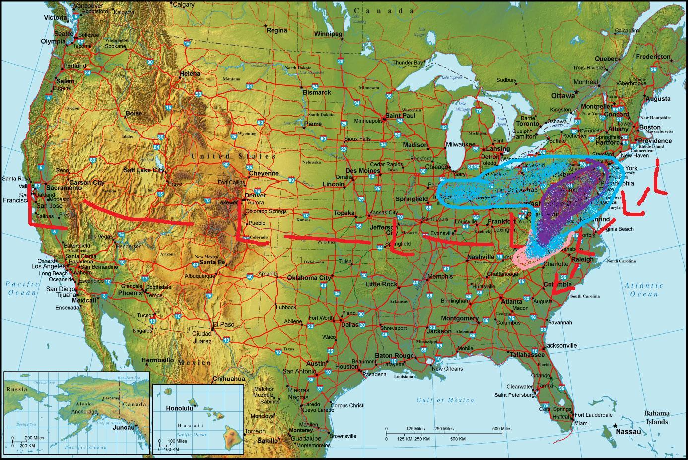
Scenario 4:  The Storm digs further North, into the Ohio Valley, redeveloping off of the DelMarva Penninsula.  This would spread heavy snow from the Shenandoah Valley of Virginia into New England, perhaps a historic storm.  With a major Ice Storm into Southern Virginia and North Carolina.  I don't think it will go this far north - however this is a significant option - much like the President's Day Storm of 2003 - a storm that burried DC. 


Scenario 5:  I won't even post a map - the storm goes well west of us and we get rain - I DON'T THINK THIS IS AN OPTION AS OF TODAY.


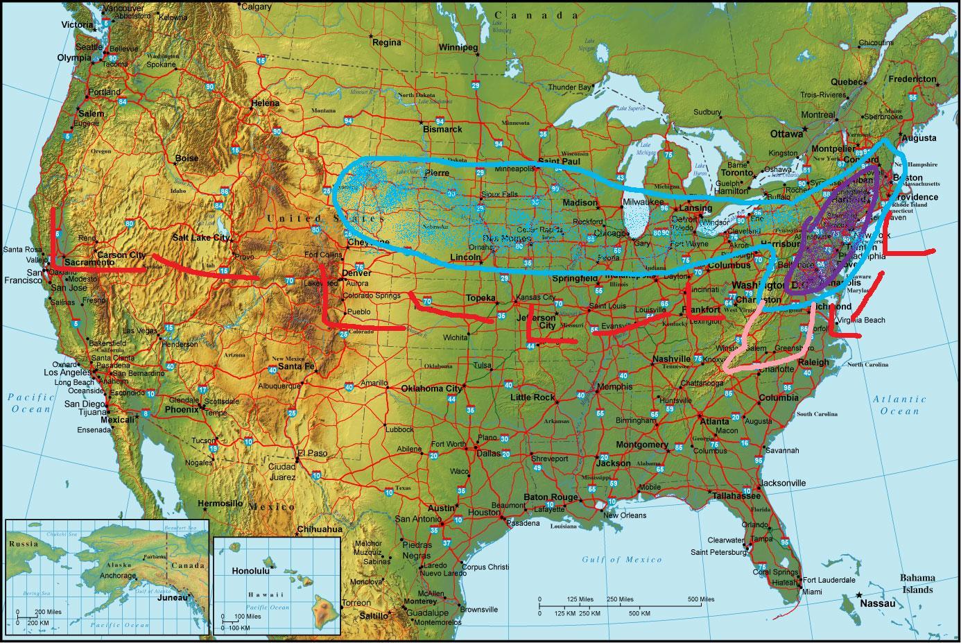
Right now, I would say the storm would do something similar or in between tracks 1 and 3, and 4.  Those seem to be the most likely tracks - anything other than that doesn't look like an option from here on out. 

So from a week away, I feel like I can farely confidentely say there is a Major Winter Storm Threat from the Southern Appalachians up to the I 95 Co-ordor Christmas Day.  Right now, I think the Southern Half of Virginia and Northern North Carolina stand a better chance of seeing ice than snow.  The best chance of snow from here looks like it will be from the Shenandoah and Alleghany Highlands of Virginia to NOVA.  There is just really no storm track that looks completely likely to miss them, and no storm track that looks warm enough to bring in ice.  A storm track surpressed to the South, like Track 2, would miss these guys out on snow, but that doesn't look likely.

I will update throughout the week.

Wednesday, December 15, 2010

Snow Map for event tommorow

Increasingly likelyhood this will be all Snow with sleet in the last few hours.  Bullseye over 460 Co-ordior - Yes Lynchburg, you will see quite a bit of snow.

Tuesday, December 14, 2010

Tale of two tracks...

Is what we will be watching all week.  There is the potential for a major snowstorm over the area this weekend.  If the storm rides up the coast, as depicted in scenario one, it will snow heavily over the entire Southern Apps.  If the storm goes further east, the snow area may needed to be shifted to the coastal plain..

Time will tell what happens.

Monday, December 13, 2010

Someone stacked the deck...

Here in Carroll County anyways.  Last weekend a clipper dropped 5" of snow.  This past weekend, a cold front supposed to be all rain, dropped around 1-3" of snow depending on your elevation.  What's so good about this you ask?  These two snows, both within a week of each other, in a La Nina winter, are very very rare exceptions.  We usually don't see accumulation of snow out of a clipper, and very very rarely, do we see a cold front come through, with just mainly snow.  Blame it on the cold air.  It has felt like February for the first half of the month, and the pattern shows no signs of letting up until after Christmas. 

-----------------------------------------------------------------------------------------------------------

The gun is loaded:

Let me try to explain this to you in simple terms.  Earlier this winter, we were seeing storm systems slam into British Columbia, and the Pacific Northwest.  It is an old saying that wherever a storm enters on the west coast, it will leave at that lattitude on the East Coast.  While we haven't seen a single Nor-Easter yet this year, we haven't had a storm dig far enough south in the Jet stream to do this.  This was the pattern til about the first of December.  However, each time a storm would run this way, the cold air, (The cold air is always in the trough, a trough is essential to storminess), it would push the trough further east. This is the pattern depicted in the picture above.  To the East of the cold front, the atmosphere was simply warm, with ridging going on.  Eventually though, the storminess, and a Block over Greenland, forced the Trough to set up over the Eastern US. ( Below)
Here we have the current pattern.  It is incredibly warm in the SW, with records being set all over the place in California.  While in the Eastern United States, the trough has set up, and given the coldest start to the Winter in recent memory.  The one problem, there is no southern storm track.  When this happens, it is hard to get snow in the winter months.  Our snows here in the South come from the Gulf of Mexico.  We are always on the fine line between snow and rain, warmth and cold, due to our lattitude.  However, we have seen a couple a system dive in from the NW that brought us several inches of snow.  Even Yesterday, we had a brief respite of the pattern described earlier, only the air was so cold on the front end of it, what is usually rain turned out to be snow in the Mountains.  This type of pattern is good, for cold weather but not for snow.  So now, onto how the gun is loaded.  I'm about to show you.

-------------------------------
We have two oppurtunities for significant winter weather over the next week.  The first will be a rather light to moderate event.  An overrunning event, that won't be a monster, but will probably cause some headaches. It's a very simple setup.  The warm air to the South will try to fight the cold air to the north.  A weak wave of low pressure will form somewhere in the Tennessee Valley, finally a Southern piece of energy, albeit weak, we will finally have a classic setup for Southern Virginia.  The problems:  It is a fast mover, and weak, and the track will be huge to if we get snow, snow and ice, ice, or rain.  Here is the setup.
Scenario One:  This is a good setup for snow in the Mid Atlantic. Ice, in the Kentucky, Tennesee Regions. Someone will get several inches.  Fine tuning where, is tough.  In the first scenario, the cold air surpresses the storm somewhat, allowing the cold air to remain along the Eastern slopes of the Appalachians, providing a significant ice storm for the Piedmont of NC and Virginia, and several inches of snow from the Mountains of North Carolina up through the entire Southern Half of Virginia. 

Scenario 2:  This is a good setup for snow over the Shenandoah into DC.  and Ice into the Southern half of Virginia, with rain over North Carolina and Kentucky.  Right now, the models are showing this scenario. 

Really, there is no difference, except the placement of the low, and how far north the warm air can intrude.  Two things: 
  1. This will be a fast mover, no one should see more than 6" of snow, or .25" of ice.  I think Virginia will get the main beef from this snow.  If it sets up North or South, or right over Roanoke, is where we have to fine tune.  One thing we could have going for us is this.  The cold air is so incredibly deep, that even if the warm air does nose in, it may not matter.  We saw this last year twice.  Two "Miller B's", (storms that traditionally bring warm air and rain), rode to the west of us, however the cold air was so deep and hard to dislodge is ended up snowing with ice at the end.  This could happen again, time will tell.  Right now, my early early call is 2-4" of snow followed by a layer of ice. 
  2. This storm sets the stage for the next one.  It could very well be a good opening act, to the main show. There are some signs showing this could be a historical storm, or a no storm.  Many of the early signals are lining up with the January 1996 storm that obliterated the Mid Atlantic. Or, it could dissappoint, and the main show might not even come to the stage at all.
I will post on this storm maybe later tonight or tommorow.  It's on and off the models.  Also, if anyone is interested in joining an in depth weather discussion, check out Kevin Myatt's Blog at Roanoke.com

Friday, December 10, 2010

Sorry for the lack of posts

I've worked 7 out of the past 8 days, and it's finals week so I've been busy.  Just a quick update.  If you read my winter outlook - I'm on track so far.  But that could change.  We have another oppurtunity at light snow this weekend, with another chance coming midweek at perhaps more significant snow.  The pattern continues to be ripe and to be honest shows no sign of letting up like I thought.  Highs Monday and Tuesday might not hit 13 degrees.  Winter is here.

I will post more beggining next week.  Everyone stay warm!

Sunday, December 5, 2010

Well, it snowed.

Abou 4" widespread.  My forecast was spot on.  I'm back at LU, and already watching the potential for another storm into next weekend.

Away from the weather some random thoughts
  • How about them Hokies?
  • Really, 8 days left at Liberty til' I'm gone for a month?!
  • I miss baseball.
  • As much as I hate the Yanks, I love Derek Jeter.  He's what baseball is about.
  • Zack Hall owes me 20 bucks.  Thats 2-0 on sports bets this fall.
  • Tech vs. Stanford - - this will be fun.
  • New post later this week. Stay warm :)

Thursday, December 2, 2010

Snow this weekend...

Here's my initial snowmap for the storm this weekend.  I will post an update later tonight.